Sunday, 11 October 2020

Standing Stones of God's Country

Carreg Samson

Of all the stone circle hunting I have done in the U.K., I have come to discover that more often than not they are found in the middle of farmer’s fields. This being the case, they aren’t always the easiest spots to locate. Opposed to what one might think, “Wouldn’t you just see a giant stone in the middle of nowhere?”

This is the case for what is known as Samson’s Stones. Not a stone circle but rather standing stones. These were also used during the neolith period to identify burial sites. PS. There is no parking near the stones unless you want to risk parking at the farm, walk down the field and hope the farmer doesn’t come out to shoot you for being on his private property…

Now where was I…oh yes, legend has it the stones are called "Samson" because Saint Samson of Dol allegedly placed the capstone in position with his little finger. Right. And the aliens created Stonehenge.

The 5000-year-old Neolithic dolmen is located half a mile west of Abercastle near the Pembrokeshire Coast Path in Wales with magnificent views of the coastline in the background. 

Top tip: Sunset is a great time to capture the stones 

Which brings me to my next stop...


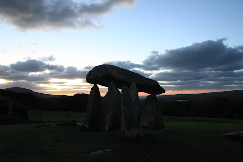
Pentre Ifan burial site at sunset (aka. The Race to Get a Picture Before Dark)


This site can be found in another field, (surprise, surprise). The stones share a pasture with a herd of brown cows that stare at tourists with their large, round eyes bewildered as to why visitors make such a fuss over stationary objects. Once the bovines know you’re not there to fed them, they MOOve on.

Ha.Ha. *clears throat.*

 You’ll be happy to know that there is parking at this location. Well, erhm….there is a small lay-by next to a plaque the size of a dinner plate, (good luck finding it by the side of road at dusk!) which declares this spot a historical monument.

After a short walk from the road, you’ll spy Pentre Ifan. One of the most impressive Neolithic burial chamber sites in Wales.  The stones’ height make them quite the impressive megalith monument. The cap stone is over 17 feet long, weighs over 16 tons and is balanced on just three support stones! I wouldn’t want to be near it on the day it capsizes!

Haverfordwest Castle


“When it rains, it pours”, who hasn’t heard that one? So whilst it’s raining best get in the car and drive off in search of more castles, right?

Haverfordwest is approximately an hour by car from Kidwelly if you want to hit them up on the same day.

History
In 1215, the English were raiding the Welsh territories but Llywellen the Great (not sure what makes him so great) left Haverfordwest Castle alone. The castle was thought to be made of stone for when the town of Haverfordwest was sacked and burnt to the ground, the castle remained impenetrable.

In 1405, the French tried to invade but Haverfordwest castle stood its ground and beat them into retreat. *Insert joke about the French surrendering here*

During the 16th century the castle fell into disrepair and during the civil war, Cromwell demanded the castle be blown to bits to finish the job.

Being repaired sometime later, the castle was used as a prison in the 19th century. Mostly filled with rioters and smugglers and the odd French POWs (so they got in after all!), the gaol was of poor conditions. No baths, toilets or infirmary and the inmates slept on straw. In 1820s a treadmill was installed so the prisoners could (exercise? No. Not that kind of treadmill) grind flour to make bread for those in the gaol. In 1878, the prison was closed and the prisoners transferred. After becoming a museum, the castle became a local county office but now stands hauntingly empty. 

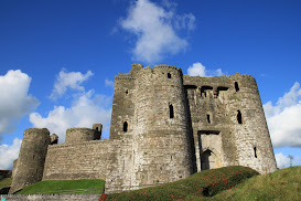
Kidwelly Castle

Ever hear the phrase, “Don’t like the weather? Wait 10 minutes. It’ll change”.


This is true of a small town named Kidwelly and especially true of its castle grounds. The fortress itself was closed to viewing but the gardens and wet lands around it were not. From the time it takes to walk around the front to the rear of the castle it went from sunny skies to dark grey clouds full of wet doom droplets.

What I learned: Nearby the castle there was a great war led by a fierce woman named Gwenllian. She was a princess by marriage and birth. He father was the Prince of Gwynedd in the 12th century. When the English King Henry I died, he had no heir.  England was left in turmoil. Wales sought their opportunity to win back their lands. Whilst her husband was away seeking more aid for the coming war, she led her doomed army against the Anglo Normans. But before losing her head, she had a son who became one of most important Welsh rulers of the times.

Also what I learned: never visit Wales without rain gear.


Saturday, 22 August 2020

Henrhyd Falls aka The Batcave

The “Henry” falls as I call them, are the tallest in south Wales with a 90 foot drop. They flow within the Brecon Beacons National Park, are free to see and contribute the “Waterfall country” of Cymru (Welsh word for Wales).
Henrhyd Falls
These waterfalls are big enough to climb behind and have a walk around in. It was here that the final scene of  The Dark Knight Rises was filmed, where it doubled as the entrance for the Batcave. (All my DC fans are drooling right now). 

Excited to see where Batman was filmed? So is everyone else. Get there early. The car park (parking lot for my Americans) is tiny and it fills up fast leaving very little parking anywhere else.

If you follow the trail below the falls it will continue on down into the forested Nant Llech valley and pass a disused watermill, the Melin Llech, with a few more smaller waterfalls along the path. The Nant Llech trail is a moderate, 3.5 mile hike which would take the usual hiker about 2 ½ hours (not counting the meandering and picture taking) to complete.

From Henrhyd Falls:

Retrace your steps back across the bridge to the path junction.

Go straight ahead, following the footpath with Nant Llech on your left-hand side.

Keep following the footpath and just after you cross a boardwalk, a smaller waterfall can be seen on your left.


Keep following the footpath until you pass through a gate which marks the end of National Trust land. Then cross a small bridge and continue to follow the path down the valley. (This is as far as I reached).

If carrying on, you reach the site of the disused watermill - the Melin Llech (these buildings are private property, NO TOUCHY). From Melin Llech, continue past the bridge on the left and follow the track uphill for about 25 yards. Join the footpath on your left and continue along this path to a kissing gate and minor road, cross the road and bear right to another kissing gate on your left.

Pass through the kissing gate then follow the path until the River Tawe comes into view. (There’s an awful lot of kissing going on if you’re on the right path). This river flows all the way to Swansea and into the Bristol Channel. You have now reached the midway point of the walk.

You can now return to the minor road by the path that you have just followed. At the road, you can either turn left uphill and follow the lanes back to the car park or, retrace the whole route back to Henrhyd Falls following the path by the Nant Llech.

Adventure awaits, where will you go?

To the Batcave!

Medieval Welsh Castle

 Once upon a time…the 11th century time…Normans invaded Wales. I think they invaded many other places but that tale for another time. During their invasion of south Wales, they built wooden “castles” which were probably more like forts. There they stood until some 200 years later when a man named Hubert came along knocking the wooden structures down replacing them with stone, erecting Skenfrith Castle.

Hubert de Burgh used the remains of the Norman castle to raise the platform in order to keep the stone castle above the flood plain as it was built right along River Monnow.  His story isn’t a happy one either. In 1201, King John gave Hubert the land to build a new shiny, stone fortress then took it away from him. Then King Henry III gave it back to him, then in 1239 he took it away from Hubert permanently. (It turns out the medieval politics are not much different than modern-day politics).

Skenfrith Castle or Ynysgynwraidd (its Welsh name), still stands today but in ruins and the only ones invading its space are the tourists. The castle’s four walls and round keep are still standing, however much of the keep has deteriorated over the years. In spite of there being no rooftop, you can still make out the three floors to the keep, now standing as a hollow tower. There are really only two ways in/out of the castle (unless you scale the castle wall-which is quite easily done; not speaking from experience…erhm..ahem)…The main entrance (where the drawbridge once lived) now has a wooden staircase up into the castle. Not really a wheelchair friendly place with its steps and uneven grounds around the courtyard. The second “entrance” leads out to the riverside. Back in the day, the river came right up to the castle wall and this was how they got their supplies inside via boat.

The castle with picnic area is very well hidden and Skenfrith will only come into view once you are pretty much upon it. If you do get lost in your search for the castle, simply follow those infamous brown signs that point to natural interest points. As a natural tourist attraction, it does not have any of the following: loos, places to eat, or shops to buy souvenirs but it’s free to see and open 24hrs. Quite literally in the midst of nowhere but a nice stopping point on your way to/from England and Wales as it’s very near the border. Also a good rest area if you are traveling to or from the Brecon Beacons back to England.

Brecon Beacon busy Bee
Busy Bee at Brecon Beacons

Viewing this castle won’t take long so if you wish to lengthen your Castle Hunting Day, try Hubert’s other nearby castles. (This guy had three)! Grosmont Castle and White Castle (not the home of cheeseburgers sadly), are all within a five mile radius of each other. Happy Hunting!